|


|
|
|
|
| This information is issued for Puerto Rico and Virgin Islands. For additional information visit the website of your Corresponding Seismological Institution or the Tsunami Warning Centers |
|
| |
|
| |
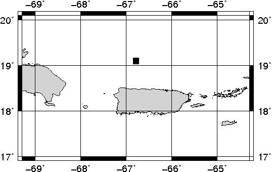
Epicentral Map(PRSN), Last Modification: 2011-11-28 07:01:33 Local Time.
| BULLETIN 2 |
| SEISMIC EVENT/TSUNAMI |
| |
| DATE: |
November 28, 2011 |
| LOCAL TIME: | 00:56:22 |
| LATITUDE: | 19.0996 N |
| LONGITUDE: | 66.7846 W |
| LOCATION: | 74 Km North-Northeast of Quebradillas,PR
77.2 Km North of Arecibo,PR
|
| DEPTH: | 12 Km |
| MAGNITUDE: | 4.9 Mb |
| ESTIMATED MAXIMUM INTENSITY: |
IV in Mayagüez, PR |
|
| TSUNAMI WARNING LEVEL: |
No tsunami threat for Puerto Rico and the Virgin Islands
|
| ISSUED DATE AND TIME: |
2011-11-28 02:59:46 |
|
The Puerto Rico Seismic Network (PRSN) received information that this light earthquake was reported as felt in Adjuntas, Añasco, Cabo Rojo, Carolina, Mayaguez, Moca and Ponce with a maximum intensity of IV (Modified Mercalli Scale, MM). At the moment of generating this bulletin no damage has been reported and is not expected to occur.
. |
|
|
|
|
| |
| |
|
| Print Version |

|