|


|
|
|
|
| This information is issued for Puerto Rico and Virgin Islands. For additional information visit the website of your Corresponding Seismological Institution or the Tsunami Warning Centers |
|
| |
|
| |
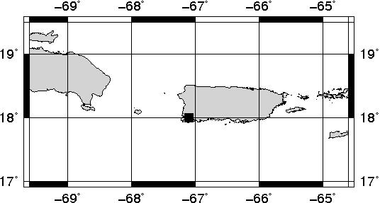
Epicentral Map(PRSN), Last Modification: 2012-07-24 07:39:45 Local Time.
| BULLETIN 2 |
| SEISMIC EVENT/TSUNAMI |
| |
| DATE: |
July 24, 2012 |
| LOCAL TIME: | 03:19:02 |
| LATITUDE: | 17.998 N |
| LONGITUDE: | 67.0971 W |
| LOCATION: | 6.5 Km West-Southeast of Lajas,PR
23 Km South of Mayagüez,PR
|
| DEPTH: | 6 Km |
| MAGNITUDE: | 3.35 Md |
| ESTIMATED MAXIMUM INTENSITY: |
III in Lajas, PR |
|
| TSUNAMI WARNING LEVEL: |
No tsunami threat for Puerto Rico and the Virgin Islands
|
| ISSUED DATE AND TIME: |
2012-07-24 03:35:07 |
|
The Puerto Rico Seismic Network (PRSN) received information that this minor earthquake was reported as felt in Cabo Rojo, Lajas and San Germán with a maximum intensity of III (Modified Mercalli Scale, MM). At the moment of generating this bulletin the event has not been reported as felt.
Remain calm, an INFORMATION STATEMENT has been issued. |
|
|
|
|
| |
| |
|
| Print Version |

|