|


|
|
|
|
| This information is issued for Puerto Rico and Virgin Islands. For additional information visit the website of your Corresponding Seismological Institution or the Tsunami Warning Centers |
|
| |
|
| |
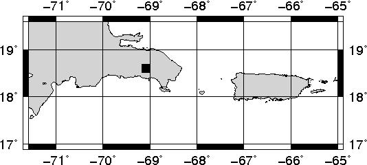
Epicentral Map(PRSN), Last Modification: 2026-09-27 22:23:45 Local Time.
| BULLETIN 2 |
| SEISMIC EVENT/TSUNAMI |
| |
| DATE: |
September 27, 2026 |
| LOCAL TIME: | 17:49:47 |
| LATITUDE: | 18.607 N |
| LONGITUDE: | 69.086 W |
| LOCATION: | 22.6 Km Northeast of La Romana,DR
222.5 Km West-Northwest of Mayagüez,PR
|
| DEPTH: | 107 Km |
| MAGNITUDE: | 4.8 Mww |
| ESTIMATED MAXIMUM INTENSITY: |
III in Mayagüez, PR |
|
| TSUNAMI WARNING LEVEL: |
No Warning, Advisory or Watch is in effect for Puerto Rico and the Virgin Islands
|
| ISSUED DATE AND TIME: |
2026-09-27 18:21:49 |
|
The Puerto Rico Seismic Network (PRSN) received information that this light earthquake was reported as felt in widely throughout Puerto Rico with a maximum intensity of III (Modified Mercalli Scale, MM). At the moment of generating this bulletin no damages has been reported and are not expected to occur.
Based on magnitude, location and historic records the earthquake was not sufficient to generate a destructive tsunami to Puerto Rico and Virgin Islands. |
|
|
|
|
| |
| |
|
| Print Version |

|