|


|
|
|
|
| This information is issued for Puerto Rico and Virgin Islands. For additional information visit the website of your Corresponding Seismological Institution or the Tsunami Warning Centers |
|
| |
|
| |
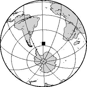
Epicentral Map(PRSN), Last Modification: 2011-12-11 11:58:08 Local Time.
| BULLETIN 0 |
| SEISMIC EVENT/TSUNAMI |
| |
| DATE: |
December 11, 2011 |
| LOCAL TIME: | 05:54:55 |
| LATITUDE: | 55.98 S |
| LONGITUDE: | 28.238 W |
| LOCATION: | 4125.6 Km East-Northeast of Coral Bay, St. John,USVI
9175.1 Km Southeast of Ponce,PR
|
| DEPTH: | 115 Km |
| MAGNITUDE: | 6.2 Mwp |
| ESTIMATED MAXIMUM INTENSITY: |
I |
|
| TSUNAMI WARNING LEVEL: |
No tsunami threat for Puerto Rico and the Virgin Islands
|
| ISSUED DATE AND TIME: |
2011-12-11 07:57:55 |
|
|
. |
|
|
|
|
| |
| |
|
| Print Version |

|