|


|
|
|
|
| This information is issued for Puerto Rico and Virgin Islands. For additional information visit the website of your Corresponding Seismological Institution or the Tsunami Warning Centers |
|
| |
|
| |
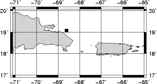
Epicentral Map(PRSN), Last Modification: 2012-04-12 00:28:36 Local Time.
| BULLETIN 1 |
| SEISMIC EVENT/TSUNAMI |
| |
| DATE: |
April 11, 2012 |
| LOCAL TIME: | 16:03:14 |
| LATITUDE: | 19.0756 N |
| LONGITUDE: | 68.6156 W |
| LOCATION: | 34.2 Km North of Punta Cana,DR
191.9 Km West-Northwest of Mayagüez,PR
|
| DEPTH: | 165.3 Km |
| MAGNITUDE: | 3.60 Md |
| ESTIMATED MAXIMUM INTENSITY: |
II in Añasco, PR |
|
| TSUNAMI WARNING LEVEL: |
No tsunami threat for Puerto Rico and the Virgin Islands
|
| ISSUED DATE AND TIME: |
2012-04-11 20:27:54 |
|
The Puerto Rico Seismic Network (PRSN) received information that this minor earthquake was reported as felt in Añasco and Mayaguez with a maximum intensity of II (Modified Mercalli Scale, MM). At the moment of generating this bulletin no damage has been reported and is not expected to occur.
. |
|
|
|
|
| |
| |
|
| Print Version |

|