|


|
|
|
|
| This information is issued for Puerto Rico and Virgin Islands. For additional information visit the website of your Corresponding Seismological Institution or the Tsunami Warning Centers |
|
| |
|
| |
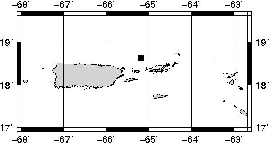
Epicentral Map(PRSN), Last Modification: 2014-08-13 18:52:53 Local Time.
| BULLETIN 0 |
| SEISMIC EVENT/TSUNAMI |
| |
| DATE: |
August 12, 2014 |
| LOCAL TIME: | 23:05:16 |
| LATITUDE: | 18.6263 N |
| LONGITUDE: | 65.1845 W |
| LOCATION: | 35.5 Km North-Northeast of Culebra,PR
99.9 Km East-Northeast of San Juan,PR
|
| DEPTH: | 73 Km |
| MAGNITUDE: | 4.6 Ml |
| ESTIMATED MAXIMUM INTENSITY: |
IV in San Juan, PR |
|
| TSUNAMI WARNING LEVEL: |
|
| ISSUED DATE AND TIME: |
2014-08-13 14:05:13 |
|
The Puerto Rico Seismic Network (PRSN) received information that this light earthquake was reported as felt in with a maximum intensity of IV (Modified Mercalli Scale, MM). At the moment of generating this bulletin no damages has been reported and are not expected to occur.
. |
|
|
|
|
| |
| |
|
| Print Version |

|