|


|
|
|
|
| This information is issued for Puerto Rico and Virgin Islands. For additional information visit the website of your Corresponding Seismological Institution or the Tsunami Warning Centers |
|
| |
|
| |
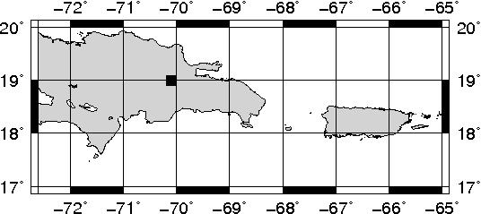
Epicentral Map(PRSN), Last Modification: 2017-02-27 01:13:39 Local Time.
| BULLETIN 1 |
| SEISMIC EVENT/TSUNAMI |
| |
| DATE: |
February 26, 2017 |
| LOCAL TIME: | 21:04:52 |
| LATITUDE: | 19 N |
| LONGITUDE: | 70.1 W |
| LOCATION: | 36.9 Km South-Southeast of San Fco. de Macoris,DR
341 Km West-Northwest of Mayagüez,PR
|
| DEPTH: | 69 Km |
| MAGNITUDE: | 4.8 Ml |
| ESTIMATED MAXIMUM INTENSITY: |
I |
|
| TSUNAMI WARNING LEVEL: |
No Warning, Advisory or Watch is in effect for Puerto Rico and the Virgin Islands
|
| ISSUED DATE AND TIME: |
2017-02-26 21:12:30 |
|
|
Based on magnitude, location and historic records the earthquake was not sufficient to generate a destructive tsunami to Puerto Rico and Virgin Islands. |
|
|
|
|
| |
| |
|
| Print Version |

|