Earthquake of 1918
INTRODUCTION
The 11th of October of 1918, the island of Puerto Rico was shaken by one of the most severe earthquakes of its history. The shaking began at 10:14 AM. According to official data, one hundred and sixteen people died, while the economic loss was calculated at four million dollars, two times the annual budget for the whole island at the time. A tsunami which was generated by the earthquake, began affecting the western side of the island within minutes of the strong ground shaking. Wave heights of up to 20 feet were observed and 40 of the deaths from the earthquake were caused by the tsunami itself.
CAUSES OF THE EARTHQUAKE
The earthquake originated in the Mona Canyon, 30 miles northwest of Aguadilla, off the northwestern coast of Puerto Rico. Several normal faults have been identified in this submarine canyon. Recent tsunami modeling performed by Mercado and others (1998) at the University of Puerto Rico at Mayagüez suggested that up to four fault segments had to have ruptured to have produced the ensuing tsunami.
AFTERSHOCKS
Almost all strong earthquakes are followed by earthquakes of lesser magnitude. These aftershocks occur as the rocks accommodate themselves to the new stress regime. With time, the frequency and intensity of these events gradually decrease, although not necessarily uniformly. Aftershocks of the 1918 earthquake were felt for up to nine months after the earthquake and on October 24 the aftershock was strong enough to knock down more buildings.
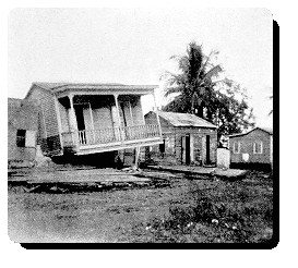
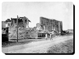 |
| Damages houses caused by the tsunami in the costal area of Mayagüez. |
SIZE OF THE EVENT
Both magnitude and intensity have been determined for this earthquake.
The magnitude is a measure of the earthquake size and can be related to the energy released. A study performed by Pacheco and Sykes (1992) calculated the magnitude of the earthquake at 7.3, which is considered major.
The strongest ground shaking was observed in the western and northwestern part of the Island, mostly due to its proximity to the epicenter. At the time of the earthquake the Rossi-Forel intensity scale was in use to determine the intensity of an earthquake, instead of the Modified Mercalli (MM) scale, which is the one presently used in the Western Hemishpere. But, for comparative purposes the corresponding MM Intensity has been determined. The strongest ground shaking occurred in Aguadilla where the intensity was VIII-IX. The ground shaking was also very intense (MM VII-VIII) in surrounding cities of Isabela, Aguada, Añasco and Mayagüez. Nevertheless, the town of Rincón which was closer to the epicenter than the aforementioned towns, suffered less damage, most probably due to the more competent ground conditions. Along the northern coast, the ground shaking was stronger in the east - west direction. In general, the intensity was stronger in the non consolidated alluvial lands that in the corresponding hard rock sites. The difference in intensity was accentuated where the water level was near the surface.
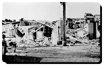
 |
| House in Mayagüez with a flat brick roof. Infront of the house we can see a concrete telephone pole broken. In the background we see the tower of the Catholic Church. |
SUPERFICIAL UNDULATIONS
A great number of observers in the areas of heaviest ground shaking reported having seen undulations on the ground surface. In a great number of the cases, these undulations were observed in low lying, water saturated lands.
LIQUEFACTION
During large earthquakes, water-saturated sands can liquefy and behave like a dense fluid, rather than a wet solid. Liquefaction can be characterized by cracks or sand boils on the ground surface. During the 1918 earthquake fountain of sands of up to 10 - 12 feet were observed during the earthquake, as well as cracks in the low lying grounds, especially in cane fields in western Puerto Rico.
LANDSLIDES
Despite the steep topography of the island, no significant landslides occurred. Rock falls occurred in areas where the intensity was VI or greater and the ground conditions, were favorable. Most of the rock falls were concentrated in the steep limestone hills near Arecibo and along the limestone cliffs along the shore of northwestern Puerto Rico.
BRIDGES
Many bridges were damaged by the earthquake and some were even destroyed.
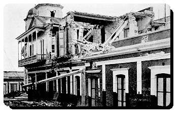
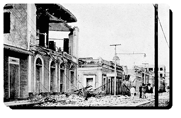
 |
| Damage to brick buildings in Mayagüez |
CHIMNEYS
In those places where the intensity reached or surpassed VI (MM) almost all the brick chimneys of the sugar mills collapsed or were seriously damaged. Those of concrete and steel had very little, if any, damage.
TSUNAMI
A significant tsunami, ocean waves which can be caused by the displacement of the seafloor during an earthquake, was generated. It reached its greatest elevation in the northwestern corner of the Island (20 feet), where it was observed almost immediately after the earthquake.
In all the places that the wave was observed, people reported that the sea first retreated, exposing in some parts, reefs and the seafloor which had never been seen, even in the lowest of tides. Afterwards, the water returned, reaching equally high elevations. At some localities, the large wave was followed by one or two smaller ones. In the closed bays the water remained disturbed for some time.
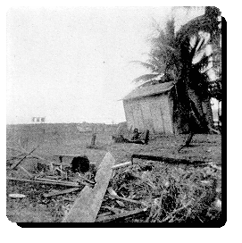 
|
| Debri at the beach in Mayagüez. Notice the house stuck against the palm tree it was pulled towards the sea by the earthquake. |
At Punta Borinquen in Aguadilla, the lighthouse keeper reported that the water began to recede during the earthquake itself and then reached an elevation of 15 feet. Near Punta Agujereada, the elevation of the wave was between 18 and 20 feet and it arrived 4 to 7 minutes after the earthquake. In the town of Aguadilla 32 people drowned and near 300 huts along the beach were destroyed. The tsunami reached Mayagüez 20 minutes after the earthquakes and had a height of 5 feet.
REFERENCES
Mercado, A. and McCann, W., 1998. Numerical simulation of the 1918 Puerto Rico Tsunami, Natural Hazards 18: 57-76, Kluwer Academic Publishers, Netherlands.
Pacheco, J. F. and Sykes, L. R., 1992. Seismic moment catalog of large shallow earthquakes, 1900 to 1989, Bulletin of the Seismological Society of America, Vol. 82, No. 3, 1306-1349.
Reid H. F. and Taber, S., 1919. The Porto Rico Earthquake of 1918. House of Representatives, 66th Congress, 1st Session, Document No. 269, November 19, 1919.
|


