For your safety, if you feel a very strong earthquake,
observe a sudden rise or fall in sea level or a tsunami
warning is issued:
Protect yourself. During an earthquake find the safest place:
drop, cover and hold. When the strong ground shaking ends, a
drastic change in sea level occurs or a warning is issued,
activate your emergency plan immediately.
Move immediately inland or to a high place out of the
danger zone. Although not all earthquakes cause tsunamis,
generate tsunamis, a strong local earthquake should be
taken as a tsunami warning.
Go on foot if at all possible. You may find traffic jams or roads
that have been blocked.
Go to the Assembly Point (A). The official assembly points are
marked with an A on the map. They have been designated by
the Emergency Management authorities, as they are located
outside the flooding area, are accessible to the community and
have the capacity to host the expected amount of people. You
may go to other places as long as they are out of the flooding
area.
A TSUNAMI MAY ARRIVE WITHIN MINUTES, BUT
LARGE WAVES AND STRONG CURRENTS MAY
CONTINUE TO AFFECT THE COASTAL ZONE FOR
HOURS.
The information in this brochure could save your life. Please
read and share it with your family, friends and co-workers.
|
What should you know and do in case of a tsunami?
A Tsunami is a series of waves generated by a large impulsive
displacement of water due to an undersea earthquake, volcanic
eruption, landslide or meteorite impact . In deep waters they can
travel as fast as 500 miles per hour, equivalent to the
speed of a commercial jet. When the tsunami approaches
the coast, its speed decreases drastically as well as the distance
between the waves, causing its height to increase up to dozens
of feet.
Puerto Rico has been affected by tsunamis in the past and could
be affected again at any moment. In 1867 , an earthquake of
magnitude 7.3 with its epicenter in the Virgin Islands generated
a tsunami with wave heights of approximately 20 feet in the
Virgin Islands and up to 5 feet in eastern Puerto Rico. In 1918 ,
an earthquake of magnitude 7.3 with its epicenter in Mona
Canyon generated a tsunami that reached 20 feet in western
Puerto Rico. In 1946 the water receded in western Puerto Rico
as a result of a tsunami generated by an earthquake in the
Dominican Republic.
In 2003, research was undertaken to evaluate all the potential
faults in the region and their capacity to generate tsunamis.
Based on these findings, tsunami inundation maps were created,
showing, for the worst case scenario, the furthest inland a
tsunami could reach in case of a local earthquake. These maps
were used as the basis for this evacuation map.
For both local, regional and distant tsunamis, remember to:
Watch out for changes in sea level. Sometimes, the
arrival of a tsunami is preceded by a sudden change of
sea level. This is the natural warning sign of a tsunami,
and should be taken as such immediately.
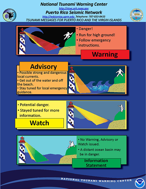
Remain alert for an emergency. A tsunami protocol
exists for Puerto Rico. Information, advisory, warning and
all clear messages will be issued depending on the
situation.
Dont be deceived. A wave could be very small in one
coastal area and extremely large a few kilometers away.
Dont be curious. You should never get close to the beach
to watch a tsunami. When the tsunami is so close that you
can see the waves, it will be too late to get out of its way.
Stay away from potentially hazardous areas. A tsunami
is not one wave, but a series of waves with several
minutes between them. Stay away from potentially
hazardous areas until the competent authorities have
issued an all clear message.
All tsunamis can be destructive. Tsunamis carry
everything they find in their path, both when flooding
and when receding.
Cooperate with the authorities. During a tsunami
emergency, the local emergency management authorities
are trying to save lives. Cooperate with them.
Be prepared. Have emergency items at hand. These should
include a first aid kit, flashlight, radio, batteries, canned food,
distilled water, important documents, etc.
|


